Summary of Constraints and Opportunities
Identified Constraints
A number of constraints have been identified – these constraints have significantly influenced the design framework that is responsive to these findings and acts to ensure that any future proposal for the site can relate to its local context.
Page 23 of the Masterplan sets out the constraints and how these relate to the site and its surroundings.
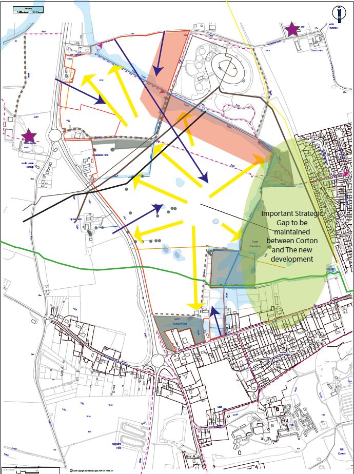
The Constraints Plan illustrates how the specific constraints relate to the site and how these have influenced the location of development.
Odour
The presence of the Anglian Water Services water treatment site and the need for a cordon sanitaire of approximately 100 metres between the margin of this site and any built development.
Natural Environment
Existing vegetation including small areas of woodland and small clusters of trees within the site boundary. The extent of these is largely modest and limited in extent relative to the overall size of the site.
Built Environment
The presence of the Grade II* listed St Batholomew’s Church to the north-east of the site. Development must not have detrimental impacts on the significance of this designated heritage asset or its setting.
Surface Water Drainage
Addressing site levels to provide a suitable surface water management and utilising the existing ditch around parts of the site that conveys water.
Utilities
Observing easements around existing utility routes across the site.
Corton
Protecting the identity of the village from encroachment and the amenity of the existing residents.
Opportunities
As well as the constraints identified above, it is important to recognise that some of these may also represent opportunities. For instance, the presence of the Listed Church of St Batholomew to the north-east provides a focal point and a connection to the area’s heritage which the Masterplan recognises and seeks to maximise the visibility of from public vantage points, while the presence of the Anglian Water treatment works and the need to provide a cordon santaire around this enables the provision of extensive areas of outdoor recreation in the area where residential development is not recommended. This also provides a buffer to the village of Corton in the east.
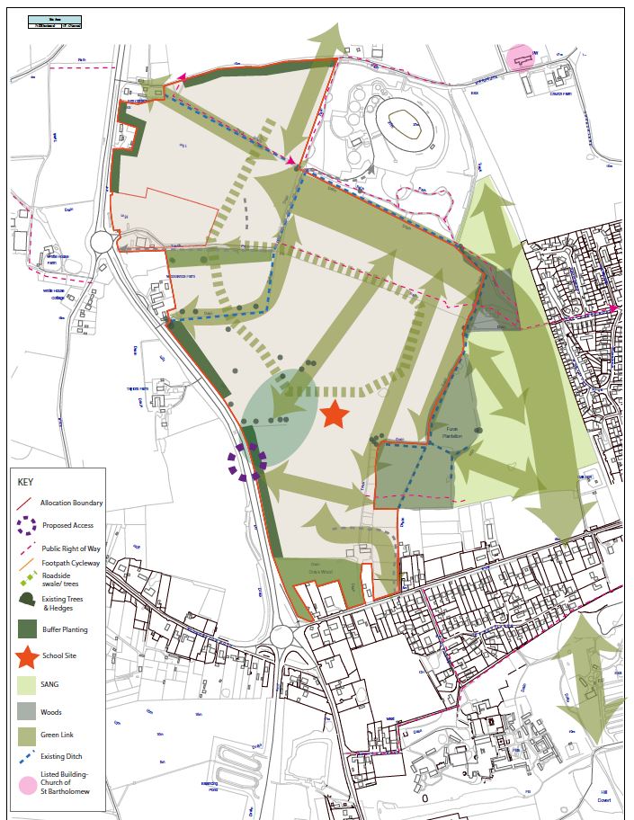
The opportunities that the Masterplan identifies can broadly summarised as follows:
Heart to the community
Providing a focus for activity and community uses within the site.
Settlement Edge
Increase significantly the level of tree cover in the area, changing from open arable fields, to landscaped areas of linear and more ad hoc tree cover to supplement the mature woodland areas and hedgerows at the edges of the site;
Place making
Create a locally distinctive sense of place.
Connectivity
Protect the existing PROW across the site, and integrate this as part of the development, whilst providing additional land in the form of the SANG, as well as new connections to Corton Long Lane to the south, and beyond towards Lowestoft and Great Yarmouth.
Views
Frame and enhance views across the site towards the St Batholomew’s Church to the north-east.
Green Corridors
Provide green corridors as a landscape structure and spine to the development with high levels of multi functional useable open space aiding movement around the development.
Habitat enhancement
Retain and enhance existing habitats through retention of existing vegetation and creation of new habitats within the SANG.
Increased Accessibility
Through a highly accessible walking and cycling network.
Movement
Integrating vehicular access throughout the site and providing links for vehicles, pedestrians and cyclists to Corton Long Lane and Stirrups Lane.
The positive attributes of the site also heavily influence the location of development.