FAQs
Frequently Asked Questions
We recognise that in the absence of face to face events you may have a number of questions having read our consultation material and therefore we have presented a series of FAQs which we hope will complete a comprehensive overview on this consultation.
This Consultation
This is a public consultation seeking views on the first consultation before the production of a Masterplan for the land north of Lowestoft, which is a strategic allocation within the adopted Waveney Local Plan (Policy WLP2.13 – ‘North of Lowestoft Garden Village) for mixed use development.
This allocation means that the principle of a mixed use redevelopment of the site has already been established and is not for consultation.
The adopted Local Plan allocates the site as and requires that a Masterplan is prepared and and consulted on in order to inform future applications for the site . This consultation is seeking views on the first consultation stages of the Masterplanning process.
At this stage we would like to hear your views about your local area and how this Masterplan can deliver a positive outcome for you and the future community. We have identified what we perceive to be among the most defining and important elements of the local area and have identified some potential Masterplan Frameworks to guide production of a Masterplan for this site. We would like your views regarding our initial findings.
For further information relating to the next stages please see below:
We are consulting with the general public and stakeholders at this preliminary stage of evidence gathering and option testing before progressing to the next stages of the Masterplanning process. This consultation commences on the 4th January 2021 and runs for a period of 6 weeks until the 15th February 2021.
We would like you to receive your feedback and encourage you to complete our online questionnaire.
This consultation is being undertaken by Suffolk County Council (Corporate Property Division) as landowner of the majority of the land allocated within the Local Plan.
MasterPlans
Masterplans are strategic long-term planning documents, which set the vision and implementation strategy for a future development. Masterplans provide a conceptual layout to guide future growth and development and will inform future planning applications. Masterplans focus on site specific strategies such as the scale and layout of development, mix and location of uses, transport and green infrastructure. Masterplans do not undertake detailed design and infrastructure planning as this is undertaken at the planning application stage but informed by the Masterplan for this site and its associated evidence base.
In the context of this public consultation, we are seeking to produce a masterplan that will guide all future development on the allocated site to the north of Lowestoft within the Local Plan. In practice, this means that any future planning applications, for parts or the whole site, will be required to ensure general conformity to the governing principles agreed within the masterplan.
The creation of a masterplan will set out a vision and strategy for the long term development of this site, and provide a conceptual master plan framework which will in turn help to raise and set the standards for future design and infrastructure provision.
The adopted Local Plan (Waveney Local Plan, March 2019) allocates the site as Policy WLP2.13 – ‘North of Lowestoft Garden Village’ and seeks mixed use development of this 71ha site comprising of the following indicative uses:
- Approximately 1,300 new dwellings;
- Retirement community comprising a care home / nursing home and extra care and/or sheltered dwellings;
- 2 form entry primary school and a pre-school setting (2.2 hectares);
- A local shopping centre comprising a convenience store, cafés, a pre-school setting, community centre and other local services;
- Playing field, play areas and green infrastructure; and
- 8 hectares of employment development (falling under use classes B1, B2 and B8).
More information concerning this allocation can be found in Waveney’s Local Plan located here:
https://www.eastsuffolk.gov.uk/assets/Planning/Waveney-Local-Plan/Adopted-Waveney-Local-Plan-including-Erratum.pdf
Nature Of The Proposals
The proposed Masterplan relates to land to the north of Lowestoft. The site is an area of 89ha of arable land (comprising the original site allocation 71ha and a significant area of Suitable Accessible Natural Greenspace 18ha) which sits to the east of the A47 to the north of Lowestoft and within the parish of Corton. The location of the site can be seen here.
A masterplan for the development of approximately 1300 dwellings, employment land, a new Primary School (including early years provision), Local Centre (containing community uses and retail), a Retirement Community (providing supported living for adults) and Playing Fields and green infrastructure that includes an area of Suitable Alternative Natural Green Space (SANG), which is a form of open space that encourages visitor recreation as part of site specific ecological mitigation to avoid disturbance to protected habitats.
This Masterplan is seeking to support the delivery of up to 1300 homes alongside the provision of 30% affordable homes. This will include the provision of a care home and extra care and/ or sheltered dwellings, which provide supported living for adults. However, the final number of homes to be provided will be confirmed within the subsequent planning applications that would follow the approval of the proposed Masterplan.
The exact housing mix and type will be established in subsequent planning applications once the Masterplan has been approved. Any housing mix proposed will ultimately be informed by the latest evidence on housing needs. This is currently being updated by East Suffolk Council and will be reviewed again as the process develops. It is envisaged that the full range of housing needs can be provided on site.
This will include traditional office, industrial and storage uses that will be complimentary to the mixed use garden village proposed.
This could include community uses, such as dentist, community hall, alongside local shopping and services such as a small convenience shop, launderettes, takeaways for example.
Suffolk County Council will deliver a new Primary School of 420 pupil places and supporting Early Years of 60 places to meet the needs of these new houses.
Yes. The Masterplan provides a well-connected network of multi-functional open spaces and formal provision exceeding 12 hectares of formal open space in addition to over 18 hectares of Suitable Alternative Natural Green Space (SANG) provision to be provided within and adjacent to the site towards Corton. Play spaces are proposed to be evenly distributed throughout the Masterplan to give good access to land north, south and east of the site and form part of larger multi-functional open space. A destination play space providing natural play is included within the SANG.
It is proposed that an internal network of ‘safe routes’ throughout the site will ensure connections to key destinations contained within it, such as the Local Centre and the new Primary school. The proposal will also ensure linkages with the existing Public Rights of Way network to facility wider accessibility for recreation.
The green corridors will integrate with the adjacent communities of Corton and Gunton providing recreation and commuting for pedestrian and cyclists (rather than being solely dependent on the highway network). These routes will provide direct connections around the site and beyond in the east-west to the SANG and Corton, Hopton, Corton Long Lane, Lowestoft town centre to the south and link to existing public rights of way connecting surrounding villages.
The public open spaces proposed will be available for use by the general public.
The promoters would seek to ensure the Masterplan subsequent planning applications reflect current and future planning policy and regulations in respect of climate change.
In particular, Suffolk County Council are seeking to incorporate a range of sustainability strategies to ensure any new developments arising in this area are sustainable and meet future climate achievement targets. This will be achieved, for instance, through the integration of sustainable design measures and minimising the use of all fossil fuel sources. East Suffolk Council also have a number of planning policies requiring sustainable construction, Sustainable Urban Drainage Systems (SUDs) and biodiversity measures aimed at addressing climate change and these will be applied to consideration of future planning applications and used to guide the Masterplan.
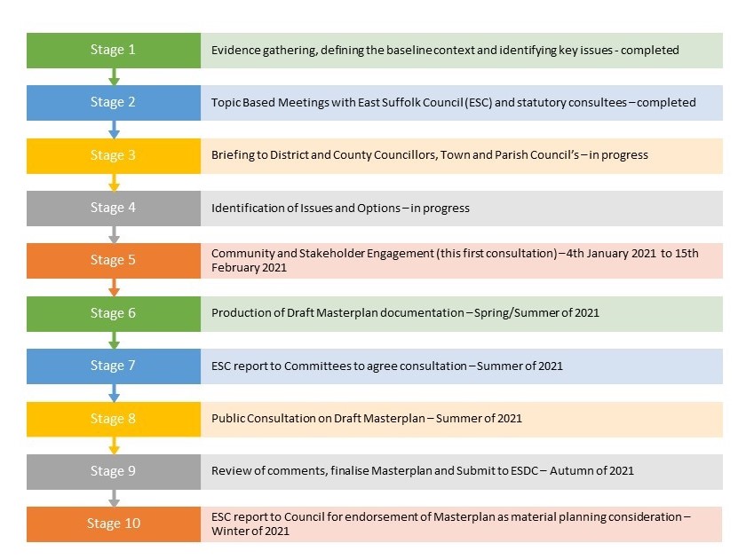
Timing and Programme
It is anticipated that the proposed Masterplan will be submitted to the East Suffolk Council (ESC) in a final form in the Autumn of 2021 seeking approval or endorsement of the Masterplan before the end of 2021.
Below is a broad indication of the Masterplan programme:
It is anticipated that planning applications could be submitted for development on parts of the site around Spring 2022 and a decision reached before the end of 2022.
Whilst a number of key decisions are yet to be made in terms of who will deliver this development it is anticipated that construction will not commence until 2024 with delivery of the first homes in 2025/2026.
It is anticipated that this development could take up to 10 years to be completed from commencement of the first phases of development.
Natural Environment
A Preliminary Ecological Appraisal report has been undertaken which identifies the site as predominantly arable land, with areas of semi-improved grassland, woodland and scattered scrub. Areas of open water were noted onsite and also recorded offsite, with both dry and wet ditches also noted within the site. Scattered trees and species-poor hedgerow were noted predominantly within boundary vegetation.
The findings of the extended Phase 1 Habitat Survey confirm that the habitats onsite have the potential to support birds (breeding and wintering), bats (roosting and foraging), Great Crested Newt, reptiles, Badger, Hedgehog, Water Vole and common assemblages of invertebrates. The site is not considered suitable for Otter or Hazel Dormice.
Accordingly to support ay planning application in the future there will be the requirement for further Surveys which include bats; great crested newts; badgers, birds, barn owls and reptiles. There will also be the need for avoidance measures and timings of works to reduce the impact of development on the site. Further survey work will be undertaken throughout 2021.
The following mitigation will be recommended in this Masterplan and used as a basis for informing the preparation of detailed proposals that will support a planning application:
- Retain existing trees and hedgerows where possible;
- Areas of semi-natural habitat such as meadows, ponds woodlands, hedgerows could be created within the scheme;
- The development should include incorporating plants that are beneficial to wildlife;
- Bird and bat bricks and boxes should be incorporated within the scheme;
- Log piles could be placed in connectivity to the any areas of semi- natural habitat within the proposals, such as woodland, meadows ponds etc;
There are four statutory designated nature conservation sites located within 2km of the site. Two of which are Local Nature Reserves (LNR), one Site of Special Scientific Interest (SSSI), one Special Area of Conservation (SAC) and one Special Protection Area (SPA). The closest of which is Gunton Warren and Corton Woods (LNR), located 690m south-east of the site, offering sand dune, shingle, lowland heath and cliff slope habitats.
Other statutory sites returned within 2km of the site included:
- Gunton Wood (LNR), located 900m south-east of the site;
- Corton Cliffs (SSSI), located 1km east of the site;
- Southern North Sea (SAC), located 825m east of the site.
In terms of internationally protected sites, the closest is the Southern North Sea (SAC), located 825m east of the site, other internationally protected sites returned within 13km of the site included:
- Broadland (Ramsar/SPA), located 9.2km north-west of the site;
- Breydon Water (Ramsar/SPA) located 9.4km north of the site;
- The Broads (SAC) located 10.6km north-west of the site;
- Great Yarmouth North Denes (SPA) located 11km north of the site;
- Benacre to Easton Bavents Lagoons (SAC/SPA) located 11.3km south of the site.
There is a potential significant effect to Broadland SPA Ramsar and the Broads SAC through impacts of air pollution (in the absence of mitigation) and there is a potential significant effect to Benacre to Easton Bavents Lagoon SAC and Benacre to Easton Bavents SPA through impacts of recreational disturbance (in the absence of mitigation).
With regard to mitigation and recommendation to offset this impact, it is proposed to mitigate the combined impacts of development in the region with a Site Nitrogen Action Plan for international sites sensitive to Air Pollution. Concerning recreational impact, a proportional financial contribution to the Recreational Disturbance Mitigation Strategy should be made, the fee for development in zone B is £321.22 per dwelling.
The provision of a SANG adjacent to the development site will mitigate any adverse effects of recreational disturbance to Benacre to Easton Bavents Lagoon SAC and Benacre to Easton Bavents SPA. These proposed mitigation strategies will be secured via a Section 106 Agreement.
Historic Environment
There are no listed buildings on site but two designated heritage assets nearby, the first of which is St Bartholomew’s Church located 440m east of the Site to the north of Corton and the second is Whitehouse Farmhouse located 140m west in the parish of Blundeston, along the Blundeston and Corton parish boundary.
The initial evidence base gathering and testing indicates that the provision of significant new areas of green infrastructure alongside the use of retained and proposed landscape buffers, retaining existing established well defined treed boundaries filtering views and sensitively designed and scaled buildings in the Masterplan can reduce the impact. These matters will be given further due consideration during the refinement of the Masterplan process.
Extensive cropmarks, which are indicative of past settlement and field enclosures, have been recorded within the site and its surrounding area. Although undated, the character of these features is consistent with a later prehistoric and Roman date. The site also forms part of the former World War II defence system for North Suffolk’s coastline. Although no longer in existence, anti-invasion trenches and systems transect the Site within its central and northern portions, and it is likely that further associated below ground remains are present within the Site.
Further archaeological investigation and mitigation measures are recommended, to be agreed in consultation with the archaeological advisor to the Council. This may include additional techniques such as geophysical survey and archaeological trial trenches. These matters will be given further due consideration during the refinement of the Masterplan process.
Technical/Existing Constraints
A review of existing technical data and site specific base line assessments has been undertaken at this evidence gathering stage of the process to inform key decisions within the Masterplan.
The constraints that would be a relevant consideration in this Masterplan are highlighted on our presentation boards and include: utilities, odour, noise, flood zones, topography and Public Rights of Way (PROW).
Our initial investigations have not identified any significant constraints to fulfilling the Local Plan objectives for this site as set out in our exhibition material.
Landscape
The development has been carefully designed to minimise landscape and visual effects, the proposal seeks to preserve the existing site landscape structure and proposes that all development will be framed and set within existing field boundaries and soft landscaped boundaries that will be enhanced with new planting and provide a linked green infrastructure throughout the site.
The landscape framework has been designed with a focus on a living landscape that benefits all. As such, habitats of importance (specifically trees, hedge rows and woodlands) will be retained, protected and enhanced within the scheme to provide improved habitat to protected species in the long term.
A network of interconnected green spaces is proposed around the retained vegetation and Rights of Way. This would link together the existing features of the site and provide a landscape framework for the development, and connect with the adjacent existing areas of woodland along the eastern boundary.
Flooding and Drainage
According to the Environment Agency’s indicative floodplain mapping, the site is classified as being within Flood Zone 1. This means that there is a low probability of fluvial (river) and/or tidal flooding (less than 1 in 1,000-year annual probability of river and sea flooding (<0.1%) in any year).
The Environment Agency’s indicative mapping for the local area also confirms that the vast majority of the site is also not susceptible to pluvial (surface water) flooding.
This will be achieved using a network of sustainable drainage systems, which control surface water runoff, ensuring the development does not increase the rate of surface water flows and flood risk on and off-site. These can work in a variety of ways, including: (i) transporting (conveying) surface water at existing greenfield rates through swales (ii) storing water in times of extreme rainfall events in basins, which allows water to soak (infiltrate) into the ground and (iii) on plot permeable areas.
The exact details of the sustainable urban drainage systems deployed will be fully detailed at the planning application stage and for this Masterplan we identify the key principles only.
The drainage strategy for this Masterplan follows Sustainable Urban Drainage System best practice and proposes a network of wet and dry basins, conveyance and treatment of surface water by swales, supplemented with pipes where necessary, and on plot permeable areas before discharging into the existing ditch network at natural surface water flow rates
Public Open Space
Substantial areas of recreation and other forms of open space, such as parks, sports pitches and play areas, will be delivered as supporting infrastructure alongside the provision of new homes within this Masterplan. The exhibition material illustrates how recreation and open spaces could be provided and integrated within the wider landscape framework and your feedback will inform the evolution of the Masterplan.
The Masterplan provides a well-connected network of multi-functional open spaces and formal provision exceeding 12 hectares of open space in addition to over 18 hectares of SANG provision. Play spaces, known as Local Equipped Areas of Play (LEAP) and Neighbourhood Equipped Areas of Play (NEAP) are proposed to be evenly distributed throughout the Masterplan and form part of larger multi-functional open spaces. A destination play space providing natural play is also included within the SANG which will be located outside, but immediately adjacent to the Masterplan site, to the east next to the village of Corton.
The purpose of the green routes is to provide a series of walking and cycling routes through a network of accessible natural green space landscaped corridors, which will also visually integrate this development into the existing landscape and break up the built form.
The green routes are areas of open space that will provide recreation and commuting for pedestrian and cyclists (rather than being solely dependent on the highway network) and provide direct connections between the built up area of Lowestoft and Hopton to the north and link to existing public rights of way connecting surrounding villages.
The green corridors will provide the primary connections between new housing, employment and proposed new areas of open spaces, childrens play, a regional SANG, local neighbourhood centre and schools.
Transport And Highways
A network of enhanced pedestrian and cyclist routes and facilities will be provided throughout the entire Masterplan area segregated from main vehicular routes to provide to create multiple safe vehicular traffic free access points and encourage non car modes of travel.
Green Routes will provide a highly accessible and connected pedestrian and cyclist network in a natural setting alongside recreation uses in vehicular free areas. Please view our exhibition material for more information.
It is proposed that the Masterplan will create a network of ‘safe routes’ that facilitate travel between the different land uses across the site without the car. It would cover key destinations such as the local centre and new Primary school, as well as public open space. The routes will also integrate with connections already established in the surrounding area to maximise connectivity.
A new traffic free route will be provided along the southern site frontage to the A47 to connect the development with the existing traffic free route along Millennium Way. Other potential improvements include new provision along the A47, south of Corton Long Lane, to link with existing interconnecting routes at Gunton Avenue. Additional improvements will be considered for the route along Foxborough Hill / Yarmouth Road, for journeys towards Lowestoft Town Centre. There is potential to provide a cycle route connection between the site and the National Cycle Route Network via Stirrups Lane to the immediate north of the site. Within the site, existing Public Rights of Way will be retained and upgraded, forming part of a highly permeable walkable and cyclable masterplan layout that maximises connections to the existing and improved local network of routes.
This consultation illustrates an indicative access and movement strategy, which is presented at a broad strategic level, relative to the evidence gathering stage of the Masterplan process being considered.
The illustrative material indicates the main movement infrastructure (pedestrian, cycle and vehicular) and where it could be located in this Masterplan to achieve a high level of integration with the town.
A new access in the form of a compact roundabout junction on the A47 is proposed to provide access to the site. However, it may also be possible to serve a modest amount of development in the southern part of the site from Corton Long Lane.
Primary site access is proposed via the A47 with secondary access via Corton Long Lane, with the vast majority of traffic using the former.
The masterplan will seek to encourage both active travel (pedestrian and cycle) for local journeys and passenger transport for both local and longer distance journeys; however, some local vehicle trips to Hopton and Lowestoft (via the A47 or Millennium Way) can be expected. Longer distance commuter journeys to Great Yarmouth or Norwich would be via the A47 (north). The A146 also provides links to Beccles and on to Norwich, and the A146 connects to the A143 at Beccles and provides links to Bungay and on to Diss.
A Transport Assessment will be prepared to accompany the forthcoming outline planning application, and this will assess the impact of the proposed development on the local highway and transport network. The assessment work will include traffic modelling of key junctions. Should any improvements to junctions be necessary to accommodate additional traffic, then suitable improvement scheme(s) will be discussed and agreed with the highway authority and implemented as part of the development. Similarly, the masterplan will encourage active travel and passenger transport by ensuring that suitable infrastructure is in place and that bus services have good area coverage and are suitably frequent to meet the needs of the development.
As above, should any improvements to key junctions be necessary to accommodate additional traffic, then suitable improvement scheme(s) will be discussed and agreed with the highway authority and implemented as part of the development. The development will encourage active travel and passenger transport by ensuring that suitable infrastructure is in place and that bus services have good area coverage and are suitably frequent to meet the needs of the development.
Our consultation material provides a brief overview of the possible mitigation that could be supported through a planning application for delivery of this Masterplan.
Initial analysis has shown that a priority ‘T’ junction access from Corton Long Lane is more than adequate in capacity terms to serve a standalone modest form of residential development up to 120 dwellings. Corton Long Lane currently carries a low level of traffic relative to its link flow capacity, and so is capable of accommodating these increases in traffic. As above, traffic modelling will be undertaken as part of the Transport Assessment in support of the outline planning application. This will include an assessment of the A47 / A117 / Corton Long Lane roundabout junction. Should any improvements be necessary to accommodate additional traffic, then a suitable improvement scheme will be discussed and agreed with the highway authority and implemented as part of the development.
Yes. As above, a Transport Assessment will be prepared to accompany the forthcoming outline planning application, and this will assess the impact of the proposed development on the local highway and transport network. The assessment work will include traffic modelling of key junctions. The scope and breadth of the document will be subject the agreement with the local highway authority and Highways England.
There is the opportunity to extend the existing bus routes to connect through this site as illustrated within our exhibition material.
The work that has informed the preparation of this application ensures that car parking will be provided in accordance with Local Plan Policy WLP8.21 Sustainable Transport and the SCC Parking Standards (May 2019) and is appropriate for the type and size of residential units provided. This will also include car parking for visitors in accordance with the requirements. The provision of electrical charging points are also being considered as part of this propsoed development.
SCC standards require a minimum of 1 space per 1-bedroom dwelling, 2 spaces per 2/3- bedroom dwelling and 3 spaces per 4+bedroom dwelling. An additional 0.25 spaces per dwelling are required as unallocated visitor provision.
In regards to cycle parking, Local Plan Policy WLP8.21 – Sustainable Transport and SCC standards are applicable and it is anticipated that garages will cater for cycle parking demand where provided, but for plots with no garage, a shed is to be provided within the garden to cater for secure cycle provision within. Should the proposal include apartments secure cycle parking will be provided.
Noise
The site is located adjacent to a small number of existing residential sites, on the northern, southern and western boundaries, with the village of Corton located further to the east, the water recycling centre to the north and the A47 to the west. These existing uses are not considered to generate significant noise and the site is considered suitable for mixed use development.
The primary source of noise is likely to be traffic from the A47, which could be addressed from on glazing specifications of the dwellings themselves or acoustic barriers if required.
An Acoustic Design Statement will be developed later on in the development of the Masterplan once detailed site layouts are available and local noise conditions have returned to normal following the Covid-19 disruption. Its purpose will be to confirm how the adverse impacts of noise will be mitigated and minimised.
Odour
The Corton Water Recycling Centre (WRC) is located immediately to the north and east of the proposed development site and presents a constraint to development on the site. However, any impacts are related to potential amenity impacts, rather than health, in close proximity to larger odour sources.
An odour constraints report has been produced to help inform the Masterplan. Consultation has taken place with Anglian water which confirms that due to existing odour mitigation already in place at the WRC, technical modelling suggests that odour impacts will not be experienced outside of 100m boundary of the WRC.
This Masterplan seeks to ensure that sensitive development, such as residential use, is not located within 100m of the WRC and a green buffer exclusion zone is proposed within this area as a suitable safeguard.
Contamination
An initial site appraisal has been undertaken which identified a number of potential sources of contamination.
Based upon the findings of the investigation, an intrusive ground investigation to determine the extent of any potential contamination within the soil is recommended.
If any contamination within the application site is identified, appropriate remedial works will be undertaken to address the sources.
Infrastructure
This site is allocated within the adopted Local Plan, which has already assessed, at a strategic level, the infrastructure requirements to deliver this mixed use allocation. Waveney’s Local Plan and supporting evidence base has confirmed that there will be no significant impacts upon the towns existing infrastructure and localised mitigation can accommodate the development proposed.
Statutory undertakers, consultees and stakeholders are being consulted through this Masterplan process which will inform strategic infrastructure planning, however, detailed assessment and infrastructure modelling will not take place until the planning application stage, following approval of this Masterplan where detailed proposals will be assessed.