FAQs

Frequently Asked Questions

We recognise that in the absence of face to face events you may have a number of questions having read our consultation material and therefore we have presented a series of FAQs which we hope will complete a comprehensive overview on this consultation.

This Consultation

This consultation concerns Suffolk County Council’s proposal to submit a Masterplan for the North of Lowestoft Masterplan, which is a strategic allocation in the recently adopted Waveney Local Plan.

Policy WLP2.13 of the Waveney Local Plan allocates the site for mixed-use development which requires that a Masterplan is prepared before planning permission is granted for any development on the site.

Suffolk County Council has previously consulted with the public in January and February 2021 concerning the background evidence base informing the production of this Masterplan, in the form of technical constraints and opportunities mapping as part of a first step ‘fact finding’ exercise. This current consultation is now consulting on the draft Masterplan, which is the next step, and has been informed by the feedback received earlier this year.

The site has been allocated for mixed-use development within the adopted Local Plan. This means decisions have already been made in support of constructing a residential led development on the land. Therefore, this consultation is seeking views on the contents of the Masterplan document, such as the vision, constraints mapping, development frameworks and implementation strategy.

Whilst we would welcome feedback on all aspects in relation to the draft Masterplan, the table below has been prepared to outline the type of feedback that can have the greatest influence over the process.

Feedback that can influence the final Masterplan

Feedback that cannot influence the final Masterplan

  • The overall vision and objectives for the site
  •  The opportunities and technical constraints that the proposal presents
  •  The design principles proposed, such as land use location, storey heights and overall densities
  • The various framework plans (site-specific strategies), such its layout and landscaping
  • The principle of mixed-use development on the site
  • The overall quantum of development proposed, such as the number of dwellings
  • The exact design specification, such as which materials should be used
  • The addition of specific details to what are high-level framework plans, such as the precise layout of the proposed land uses or the exact housing mix.

This consultation commences on the 22nd April 2022 and runs for a period of 8 weeks until 17th June 2022. We would like you to receive your feedback and encourage you to complete our online questionnaire.

The first public consultation event, which ran between 4th January and 15th February 2021, concerned the background evidence base that would inform the production of this Masterplan, and was focused around the technical constraints and opportunities mapping as part of a first step ‘fact finding’ exercise.. A variety of feedback was received from both the general public and statutory consultees (e.g. Natural England and Corton Parish Council) during this period.

The feedback received from this process has informed the detail of the Masterplan. For instance, greater consideration has been given to the areas around the boundary with the water treatment works to the north-east in order to ensure that this area is used entirely for non-residential uses and that a separate access is created for the employment land area.

It is the purpose of this second public consultation to seek the views on the draft version of the Masterplan.  Any comments received during this process will be actively considered by the project team and will be incorporated into the final version of the proposed Masterplan where appropriate.

The feedback received from the first public consultation event has assisted in shaping the evolution of the Masterplan. All of the comments provided by respondents have been carefully considered and refinement to the Masterplan has been made as a result.

It is not always possible to address each comment made as some community concerns or suggestions will not always be aligned with local or national planning policy, and therefore there will be other competing interests.

The key themes emerging from the previous consultation exercise which have informed the evolution and development of the Masterplan include the issues which have broadly been summarised below:

  • Providing a greater level of information about the four key areas that form the basis of the Landscape Framework
  • Prioritising pedestrian and cycle connectivity – to integrate the site with its surroundings, ensure safe movement routes and corridors, and minimise the use of the car for travel;
  • Carefully consider access – onto Corton Long Lane;
  • Establish a clear ‘community hub’ – around the primary school, local centre and retirement community;
  • Managing the risk of odour – through appropriate land use planning and further evidence gathering;
  • Provide accessible green infrastructure – contributing to a green, leafy garden village character;
  • Distinctive design – identifying character areas, appropriate density, streets, landscape and open space;
  • Exploring low carbon design – pursuant to SCC commitment to respond to the climate emergency; and
  • Infrastructure planning – with key service providers to mitigate impacts.
  • The disclosure of the intended approach towards delivering the proposed land uses through identifying four broad phases of development.

The preparation of the Masterplan for the North of Lowestoft Garden Village is an extensive process that spans from initial evidence gathering to its eventual consideration and adoption by East Suffolk Council as a material planning consideration. A flow chart, below, has been prepared to illustrate this process.

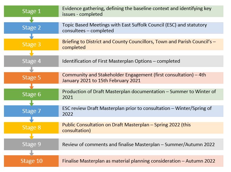
This current consultation event is denoted by Stage 8 on the flow diagram.

Once the event has been completed, the comments will be actively reviewed by the project team to inform the final framework plans that will comprise the final version of the proposed Masterplan (Stage 9).

Finally, the document will be submitted to East Suffolk Council for review (Stage 10). If approved, it will inform the extent, character and strategic form of the development and provide guidance for developers and designers in delivering best practice in architecture, urban design, landscape, and sustainability.

This consultation is being undertaken by Suffolk County Council (Corporate Property Division) as landowner of the owner of the land which has been allocated for development in the Waveney Local Plan.

Phase 2 Planning & Development have been appointed to manage the process on behalf of the Council and will provide the primary point of contact at this stage of the process.

MasterPlans

Masterplans are strategic long-term planning documents, which set the vision and implementation strategy for a future development. Masterplans provide a conceptual layout to guide future growth and development and will inform future planning applications. Masterplans focus on site specific strategies such as the scale and layout of development, mix and location of uses, transport and green infrastructure. Masterplans do not undertake detailed design and infrastructure planning as this is undertaken at the planning application stage, which would follow East Suffolk Council’s approval of a Masterplan for this site.

In the context of this public consultation, we are seeking to produce a masterplan that will guide all future development on the land allocated as part of the Garden Village. In practice, this means that any future planning applications, will need to accord and have regard to principles set out in the Masterplan.

The Masterplan will set out a vision and strategy for the long-term development of this site and provide a conceptual framework which will in turn coordinate and help to raise and set the standards for future design and infrastructure provision.

The Waveney Local Plan’s vision for the North of Lowestoft Garden Village is that it is ‘designed using garden city principles with significant amounts of landscaping, tree planting and green infrastructure.’

The Town and Country Planning Association (TCPA) academic research papers have concluded that a Garden City is:

‘a holistically planned new settlement that enhances the natural environment and offers high-quality affordable housing and locally accessible work in beautiful, healthy and sociable communities.’

The TCPA have established 9 key guiding Garden City principles, aimed at new settlements of 10,000+ houses, as follows:

  • Land value capture for the benefit of the community.
  • Strong vision, leadership and community engagement.
  • Community ownership of land and long-term stewardship of assets.
  • Mixed-tenure homes and housing types that are genuinely affordable.
  • A wide range of local jobs in the Garden City within easy commuting distance of homes.
  • Beautifully and imaginatively designed homes with gardens, combining the best of town and
  • country to create healthy communities, and including opportunities to grow food.
  • Development that enhances the natural environment, providing a comprehensive green
  • infrastructure network and net biodiversity gains, and that uses zero-carbon and energy positive
  • technology to ensure climate resilience.
  • Strong cultural, recreational and shopping facilities in walkable, vibrant, sociable
  • Integrated and accessible transport systems, with walking, cycling and public transport
  • designed to be the most attractive forms of local transport.

Garden City principles are sound guiding principles but are to be applied proportionately to the garden village concept in light of the difference in scales and types of development being delivered.

The Waveney Local Plan which allocates the site for development refers to the site as the North of Lowestoft Garden Village, and requires that the development of the site meets Garden City principles. These are reflected throughout the masterplan for the site with the following elements of garden city planning evident in the approach to planning of the site:

  • Providing well connected and well-designed areas of open space that is accessible for all, set within a landscape led structure that responds sensitively at the edges of the proposed development
  • A range of amenities which are assets for the community rather than simply commercial operation
  • Mixed tenure homes and housing types, including the provision of genuinely affordable housing
  • Enhancing the natural environment through the provision of green infrastructure.
  • Retention and enhancement of important existing habitats, with the creation of additional grassland areas, tree and hedge planting, creation of new ponds, and establishing a lasting management regime within a new SANG.
  • Prioritising walking and cycling and access to public transport, responding to identified desire routes and safely connected off-road links between Lowestoft and Hopton, and by using public transport with the existing town
  • Minimising the need for journeys by private cars and reducing the need for this through the provision of a mix of uses in close proximity
  • Delivering housing which well-designed and which contributes to well-functioning and aesthetically pleasing places and public spaces Focal local centre, education facilities, and employment within walking distances of homes.

The Waveney Local Plan (adopted March 2019), allocates the site as North of Lowestoft Garden Village.  Policy WLP2.13 identifies the site as follows:

Land comprising the North of Lowestoft Garden Village (approximately 71 hectares) as defined on the Policies Map is allocated for a comprehensive mixed use development including:

  • Approximately 1,300 new dwellings;
  • Retirement community comprising a care home / nursing home and extra care and/orsheltered dwellings;
  • 2 form entry primary school and a pre-school setting (2.2 hectares);
  • A local shopping centre comprising a convenience store, cafés, a pre-school setting,community centre and other local services;
  • Playing field, play areas and green infrastructure; and
  • 8 hectares of employment development (falling under use classes B1, B2 and B8)

More information relating to the allocation of the land in the Waveney Local Plan can be found here:  https://www.eastsuffolk.gov.uk/assets/Planning/Waveney-Local-Plan/Adopted-Waveney-Local-Plan-including-Erratum.pdf

Nature Of The Proposals

The proposed Masterplan relates to land to the north of Lowestoft and to the west Corton. The site is an area of 71 hectares of predominantly arable farmland between the A47 to the west, Corton Long Lane to the south and Stirrups Lane to the north. The location of the site can be seen here. The location of the site can be seen here.

A masterplan for the development of approximately 1300 dwellings, 8 hectares of employment land, a new Primary School (including early years provision), Local Centre (containing community uses and retail), 80 bed Adult Care Services (providing supported living for adults) and 23 hectares of Suitable Alternative Natural Green Space (SANG), which is a form of open space that encourages visitor recreation as part of site-specific ecological mitigation to avoid disturbance to protected habitats.

This Masterplan is seeking to support the delivery of around 1300 homes including the provision of 30% affordable homes. In addition, the policy seeks the provision of a retirement community comprising a care home/nursing home and extra care and/or sheltered dwellings.

The final number of homes to be provided will be confirmed within the subsequent planning applications that would follow the approval of the proposed Masterplan.

The exact housing mix and type will be established in subsequent planning applications once the Masterplan has been approved.  The mix of housing provided will have regard to the latest evidence on housing need to ensure that what is provided reflects the level of need for both market and affordable housing in the area.  

The exact mix of employment is not known at this stage, however, it is anticipated that a new business park will be created, providing much-needed space for business and investment in this part of the town. The mix of uses may include traditional office, industrial and storage uses that will be complimentary to the key growth industries such as the offshore and renewable energy sectors.

This could include local shops, such as dentist, a small convenience shop, launderettes, takeaways and an early years facility. The exact type and size of uses will be determined through future planning applications.

The need and desire for new medical facilities expressed by respondents to the first consultation has been noted and efforts will be made to secure the provision of new facilities as part of the development, either directly, or through financial contributions towards the enlargement or enhancement of existing facilities by providers to cater for increased demand.

Suffolk County Council will deliver a new Primary School of 420 pupil places alongside pre-school care provision for 60 full-time equivalent places.  The County Education Authority have also indicated that a second new 60 place ‘Early Years’ setting is likely to be required to account for the demand arising from the completed development.  

Yes.  The Masterplan seeks to provide a well-connected network of multi-functional open spaces.

The development would also provide a network of green corridors within and around the site which will reflect the context of its presence at the northern edge of Lowestoft and the fact that this is currently an area where agriculture is the predominant land use.

The new green infrastructure will provide corridors for wildlife as well as providing safe movement and access to recreation for residents and those working or visiting the area. This green infrastructure will be managed in such a way that there would be a net gain biodiversity.

In addition, a further 23 hectares will be provided alongside the allocated development site as part of the area of Suitable Alternative Natural Green Space (SANG) provision on the land directly to the east, between the developable area of the site and the existing housing at Corton.  

It is anticipated that new areas of children’s play will be provided at a range of locations throughout the site. These will need to be distributed so as to ensure that they are accessible to future residents.  It is proposed that a destination play space will be provided within the SANG.

All of the areas of public open spaces that it is proposed to be provided within the site and as part of the SANG directly to the east, will be made available for use by the general public.

The promoters would seek to ensure through the Masterplan that subsequent planning applications reflect current and future planning policy and regulations in respect of climate change.

The following key principles will be considered through the masterplan and planning process:

Urban Design

  • Pedestrian and cycle friendly urban designs that encourage non car use
  • Connections to existing PROWs and creation of new PROWs
  • New connections to public transport routes beyond the allocated site
  • Strategic integration of SUDS into masterplan
  • Green corridors and green infrastructure throughout the site

Housing Design & Build Standards

  • Low carbon heating systems
  • Fabric first construction principles and energy efficient design
  • Orientation and thermal comfort considered as part of design
  • On site generation
  • Energy infrastructure to allow for electrical vehicle charging and peak demand management
  • Water efficiency on site through low flow fittings

Materials and waste

  • Reduced Embodied carbon through local sourcing of materials and reduction of waste where possible

Timing and Programme

It is anticipated that the proposed Masterplan will be submitted to the Council in the Autumn of 2022 with the intention of obtaining approval shortly after.

Below is a broad indication of the Masterplan programme:

It is anticipated that planning applications could be submitted for development on either all or parts of the site following the adoption of the Masterplan. If this proceeds as currently anticipated then an application could be made during the winter of 2022/23 with a decision anticipated in Summer 2023.

Whilst a number of key decisions are yet to be made in terms of who will deliver this development it is anticipated that construction will not commence until 2024/25 with delivery of the first homes in 2026/2027.

It is anticipated that this development could take up to 10 years to be completed from commencement of the first phases of development.

Design and Character Areas

The proposed Masterplan provides guidance which it is intended will inform and set the parameters for the detailed design process which will follow as part of formal proposals for planning applications.

This material has been informed by an analysis of the existing built form in the northern areas of Lowestoft and the surrounding villages including Corton, Blundeston and Lound, which have positive and distinctive characteristics. The most attractive and distinctive elements of these areas which define their character have been recognised in the Masterplan as being among the best examples of successful place-making in the area. This analysis of the context has informed the guidance which seeks to ensure that the proposed Masterplan recognises that elements of existing built form provide the context in which the proposed Garden Village will be set.

Pages 48 – 64 of the Masterplan provide design guidance which sets the parameters within which will guide the form, scale and distribution of development across the site. The guidance focuses primarily on setting out three sets of ‘rules’ that development across the site is expected to comply with. These include:

  1. Density – There are three density bands setting a range of densities for different parts of the site, measured in dwellings per hectare (dph). Density focusses on the built form.
  2. Edges and Green Corridors – There are four different edge conditions and two corridors. Each has guidance on the interface between the green spaces and the built form. Edges and Green Corridors focusses on the landscape.
  3. Character Areas – There are four character areas. Each has guidance on the density, height, boundary treatments and predominance of certain materials. Character Areas focus on thebuilt form and the landscape.

Guidance in relation to these areas and others will provide three dimensional frameworks within which future designers will provide detail in relation to the layout, architecture and appearance of buildings, as well as the details of landscaping and planting.

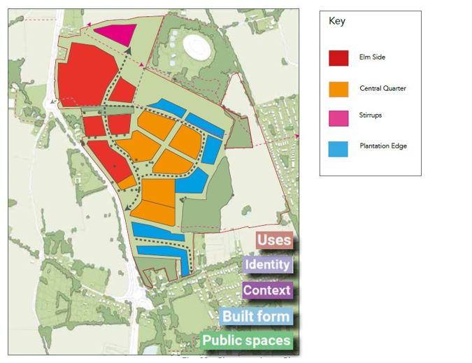
The Masterplan has identified four different character areas, each with a distinctive and unique identity based on a predominance of particular features including:

  • Density
  • Storey heights
  • Boundary treatments
  • Landscape character
  • Architectural styles and external materials; and
  • Building typologies

Each Character Area is made up of a number of urban blocks and careful consideration will be given to the locations where character areas adjoin one another.

In addition the Key Characteristics that can be found in Corton, Lowestoft and surrounding villages such green streets, tight knit streets and high streets will be interspersed throughout the development to root it in its location.

The Character Areas Framework Plan contains four different character areas: ‘Elm Side’, ‘Central Quarter’, ‘Stirrups’ and ‘Plantation Edge’. Each of these areas will have its own distinctive identify which will be based upon a predominance of certain features including, but not limited to, architectural materials and storey heights. Full information on these areas is detailed on pages 60 – 64 of the proposed Masterplan.

These are shown in the Character Areas Plan below.

This high-level design has been created in accordance with the National Design Guide which sets out the characteristics of well-designed places and demonstrates what good design means in practice.

In line with the requirements of both current and future planning policies, a broad range of principles relating to sustainable design will be adopted to meet the key challenges of the transition away from a reliance on fossil fuels for heating and powering homes and for transport.  

All dwellings will be built according to the 2025 Future Homes Standard. This entails achieving an exemplary fabric performance, through the incorporation of high levels of insulation and high-performance glazing, well beyond current building regulations standards. The adoption of such rigorous energy efficiency measures will lead to an overall reduced energy demand for heating.

Sustainable construction methods such as offsite construction, where significant reductions in waste and carbon can be achieved, as well as substantial reductions in build time, will be considered. It has been shown that homes built using these methods have fewer defects and far lower heating bills.

Each dwelling will also be fitted with an Electric Vehicle (EV) charging point as well as a minimum of 15% parking provision in public spaces. All charging points will be Vehicle to Grid (V2G) in order to enable demand response capability, where electricity can be taken from the grid at times of high demand, but fed back into the grid at times of low demand, thus smoothing out the overall demand, and taking advantage of the much greater storage capacity of vehicles over that of a standard battery. The full range of measures are detailed on pages 67 – 70 of the draft Masterplan document.

Natural Environment

The site comprises predominantly arable land, with areas of semi-improved grassland, woodland and scattered scrub. Areas of open water are noted onsite and also recorded offsite, with both dry and wet ditches. Scattered trees and species-poor hedgerow (intact and defunct) are noted predominantly within boundary vegetation. These habitats have the potential to support some protected species and will require mitigation within the design.

Further detailed survey work will be undertaken ahead of detailed design work which will inform aspects of the layout. Any areas of the site that will undergo change as part of the proposals will be subject to scrutiny as part of the planning process.

The mitigation measures listed below are currently envisaged, and the Masterplan recommends that these are used as a basis for informing the preparation of detailed proposals that will support a planning application:

  • Retain existing trees and hedgerows where possible as to ensure the preservation of existing habitats on site such as field margins;
  • The open green spaces retained as part of the development will be connected through the use of green corridors to provide for the movement of animals and the continuation of viable populations;
  • Landscaping will be designed to allow bats to continue foraging and roosting in the area.

Overall, it is the purpose of these measures to ensure that the scheme achieves a biodiversity net gain. In other words, the level of biodiversity achieved through the development of the site will be greater than it is at present. This is among the Garden City principles which inform the overall strategy, and a key component of the vision for the site as detailed on Pages 10-11 of the proposed Masterplan.

There are thirteen non-statutory designations are within the 2km search radius. The closest of which is Corton Woods (CWS), located 690m south-east of the Application Site, offering scrub, woodland, grassland and open water habitat for local wildlife.

Four statutory designated nature conservation sites are located within 2km of the Application Site. Two of which are Local Nature Reserves (LNR), one Site of Special Scientific Interest (SSSI), one Special Area of Conservation (SAC) and one Special Protection Area (SPA). The closest of these is closest of which is Gunton Warren and Corton Woods (LNR), located 690m south-east of the Application Site, offering sand dune, shingle, lowland heath and cliff slope habitats. Corton Cliffs is a geological SSSI.

Six Habitats sites are present within 13km of the Application Site, including: Southern North Sea (SAC), located 825m east of the Application Site.

In recognition of the presence of these protected sites, which may be subject to additional pressures as a result of the presence of additional homes, the provision of a suitable accessible natural greenspace (SANG) a suitable accessible natural greenspace (SANG) will be included within the proposals.

The presence of the SANG will mitigate and offset the potential of adverse impacts from development, not only from within the Masterplan area but in combination with other development in the region.

Historic Environment

The most prominent listed building is the Grade II* Listed Church of St Batholomew to the north-east of the site.  

The primary focus of built heritage is the Grade II* listed St Batholomew’s Church to the north-east of the site. The building and its immediate curtilage is approximately 500 metres from the closest part of the site, and it is notable that there are significant areas of intervening vegetation. The setting of this important statutorily listed building will be an important consideration in the design of the development. The Masterplan acknowledges this and seeks to ensure that views towards the site are possible from a range of vantage points within the site.

The Local Plan anticipates that this site has high potential for archaeology. However, initial evidence supported by a geophysical survey indicates that the potential for below-ground remains would not be of the highest level of heritage significance, and therefore not demanding preservation in situ. It is, rather, anticipated the archaeological remains within the site are of regional and local significance. However, an archaeological evaluation, and proposals for managing any impacts will be undertaken to inform a future planning application.

Technical/Existing Constraints

The constraints that would be a relevant consideration in this Masterplan include utilities, odour, noise, flood zones, topography and Public Rights of Way (PROW). The constraints to development have been mapped in Figure 10, which appears on Page 23 of the draft Masterplan. The key constrains are also listed and described in more detail below this Constraints Plan.

Landscape

The Landscape Framework has been designed with a focus on a multi-functional living landscape that benefits all. As such, habitats of importance (specifically trees, hedgerows and woodlands) will be retained, protected and enhanced within the scheme to provide improved habitat to protected species in the long term.

Particular attention has been afforded to the provision of Green Spaces and Corridors in the Masterplan. Six zones with particular visual characteristics based on the presence of or proximity to existing areas of vegetation have been defined in the Masterplan. These are described in detail on Pages 53 – 59.

The intention is to retain as much of the existing vegetation as possible. The opportunity exists to supplement this with new planting in areas which are currently open fields. It is anticipated that the Garden Village will comprise of extensive landscaped areas providing new areas of tree cover as an integral part of the development of the site.  

The Masterplan seeks to provide a series of interconnected ‘Green Edges’ and ‘Corridors’ as part of a network of landscaped open spaces within and adjoining the allocated site reducing the prominence of any new built form integrating the development into the landscape.

The orientation of linear open spaces seeks to provide views through and from areas of the site towards St Batholomew’s Church to the north-east while maintaining separation between the new development and the setting of this designated heritage asset. 

Flooding And Drainage

The Environment Agency’s indicative floodplain mapping confirms that the entire site is classified as being within Flood Zone 1. This means that there is a low probability of fluvial (river) and/or tidal flooding (less than 1 in 1,000-year annual probability of river and sea flooding (<0.1%) in any year). 

The Environment Agency’s indicative mapping for the local area also confirms that the vast majority of the site is not susceptible to pluvial (surface water) flooding, with those areas that are at risk are comprised primarily of linear areas around the north and east of the site where there is a ‘Low’ risk of surface water flooding. There are however a small number of isolated of patches which are susceptible to higher risk of pluvial flooding. This means that the risk of flooding in any given year is above 3.3%. For that reason, it is important that the existence of these areas (while small in extent), is recognised and incorporated into the design and layout of development.

This will be achieved using a network of Sustainable Drainage Systems (SuDS), which control surface water runoff, ensuring the development does not increase the rate of surface water flows and flood risk on and off-site.

SuDS will manage rainfall at source by ensuring that surface water is discharged into the ground via infiltration techniques where possible, considering an allowance for future climate change. Where infiltration is not possible, the remaining surface water will be conveyed to the nearest basin, where it will slowly enter the existing watercourse managed by a suitable designed flow control system.

To achieve this, a number of drainage measures are proposed to manage and control water flows across the site which include:

  • Plot attenuation for some of the non-residential land uses;
  • Shallow, wide, swales (specifically designed drainage ditches) that convey surface water and allow infiltration; and
  • Shallow, large, open, attenuation basins (dry basins) that hold water within the site at times of heavy rainfall.

The dry basins will operate a 48 hour drain-down rate (but are otherwise dry and usable at all other times) and enable water to be released at a steady rate.

The exact details of the sustainable urban drainage systems deployed will be fully detailed at the planning application stage and for this Masterplan we identify the key principles only.

Public Open Space

Substantial areas of the site will be provided as open spaces both for amenity value and to provide convenient access to areas of outdoor recreation.  The provision of extensive areas of ‘Green Infrastructure’ would provide areas for sport, recreation, formal and informal open spaces alongside areas used to provide sustainable drainage systems. The location of green open spaces have generally been proposed in order to reflect the presence of existing mature vegetation, in particular the areas of woodland at the margins of the site.

Among the key principles of the landscape framework plan is the retention of the majority of the existing mature vegetation, including linear rows of trees, and isolated or sporadic areas of tree cover and the integration of new open spaces with the existing pockets of woodland located around the edges of the site. The open spaces extend out of the site onto the adjoining land to the east which will be provided as a SANG. The SANG, whilst intended to serve as ecological mitigation, will provide a substantive buffer preventing the coalescence of the Garden Village and the village of Corton, and thereby preserving the identity of the latter.

A key green corridor provides a direct link through the site starting at the main access with the A47, passing through the local centre and continuing through to the north-east boundary following the view corridor of the St Batholomew’s Church tower.

The purpose of the green routes is to provide a series of walking and cycling routes through a network of accessible natural green space landscaped corridors, which will also visually integrate this development into the existing landscape and break up the built form.

The green routes are areas of open space that will provide recreation and commuting for pedestrian and cyclists (rather than being solely dependent on the highway network) and provide direct connections east-west across the site, linking to Corton to the east and the countryside to the west of the A47.  

The green corridor forms a link to the wide, linear green spaces around the north, east and southern edges of the site. This area will contain areas of multi functional landscape including sustainable urban drainage basins and playing fields. A buffer zone is provided along the western boundary of the site where it adjoins the A47 in order to reinforce the existing treeline and create a wooded edge to the site. Other green routes are provided along the wooded edges of the site and along the route of the gas main easement, creating an interconnected network of open spaces.

Transport And Highways

This consultation includes an Access and Movement Plan (provided at Figure 16 of the draft Masterplan document), which illustrates how and where it is anticipated traffic movements will take place across the site.  The hierarchy of routes comprised of Primary Streets and Secondary Routes which would facilitate the distribution of traffic accessing the residential areas of the site, the proposed Local Centre and other uses including the Primary School and Early Years facilities and Adult Care Services.

The illustrative material indicates the main movement infrastructure (pedestrian, cycle and vehicular) and where it could be located in this Masterplan to achieve a high level of integration between the new development and the existing settlements of Corton to the east and Lowestoft to the south.

It is currently anticipated that a new access in the form of a compact roundabout junction on the A47 is proposed to provide access to the site. However, it may also be possible to serve a modest amount of development in the southern part of the site from Corton Long Lane. The Highways Authority have also identified the need for an additional vehicular access that will need to be provided for emergency access. The need for this has been acknowledged and reflected in the draft Masterplan.

Full details of the proposed Transport and Movement arrangements including the Access Strategy are provided on Pages 42 – 45 of the draft Masterplan document.

A new traffic free route will be provided along the southern site frontage to the A47 to connect the development with the existing traffic free route along Millennium Way. Other potential improvements include new provision along the A47, south of Corton Long Lane, to link with existing interconnecting routes at Gunton Avenue. Additional improvements will be considered for the route along Foxborough Hill/Yarmouth Road, for journeys towards Lowestoft Town Centre. There is potential to provide a cycle route connection between the site and the National Cycle Route Network via Stirrups Lane to the immediate north of the site connecting with the expanding Broadland Sands Holiday Park. Within the site, existing Public Rights of Way will be retained and upgraded, forming part of a highly permeable walkable and cyclable masterplan layout that maximises connections to the existing and improved local network of routes.

The existing east-west links across the site in the form of the public footpath (Corton PROW Number 3), will be significantly enhanced providing access to Corton and the amenities within the village. This is not currently suitable for cyclists, pushchairs or persons with impaired mobility who make use of wheelchairs or mobility scooters. Providing well-lit, even and equitable access within and through the site will be an important positive feature of the scheme.

Improved bus service provision will be key to ensuring that the proposed Garden Village is accessible by a range of modes of transport.  It is envisaged that public transport infrastructure enhancements and strategy that will create additional capacity within the existing transport network to accommodate the development without adverse impacts and help to encourage a modal shift in the movement of commuters between Great Yarmouth and Lowestoft.

As part of this strategy bus travel will be promoted and designed to accommodate buses travelling through the site and using a bus only gate between the main site and Corton Long Lane, while bus stops will be provided within 400 metres walking distance of the dwellings, open space, schools, and local centre.

A Transport Assessment will be prepared to accompany forthcoming planning applications for this site, and this will assess the impact of the proposed development on the local highway and transport network. The assessment work will include traffic modelling of key junctions. Should any improvements to junctions and the wider network be necessary to accommodate additional traffic, then suitable improvement scheme(s) will be designed with the highway authority and implemented as part of the development.

It is currently anticipated that a new access in the form of a compact roundabout junction on the A47 is proposed to provide access to the site. However, it may also be possible to serve a modest amount of development in the southern part of the site from Corton Long Lane. The Highways Authority have also identified the need for an additional vehicular access that will need to be provided for emergency access.

Noise

The site is located adjacent to a small number of existing residential sites, on the northern, southern and western boundaries, with the village of Corton located further to the east, the water recycling centre to the north and the A47 to the west. These existing uses are not considered to generate significant noise and the site is considered suitable for mixed use development.

The primary source of noise is likely to be traffic from the A47, which could be addressed by the glazing specifications of the dwellings themselves or acoustic barriers if required.

Residential development is not considered to result in any impacts relating to noise generation. The employment uses which would have the greatest potential for noise impacts on existing homes, would be located in an area adjoining the A47 where there would be effective separation between this and any areas of new housing to be provided as part of the Garden Village.

The Local Centre is not anticipated to result in any adverse impacts from noise given the nature of the uses proposed which would be comprised of uses that are compatible with residential accommodation.

Any future planning application will be supported by an Acoustic Design Statement. Its purpose will be to confirm how the adverse impacts of noise will be mitigated and minimised.

Odour

The Corton Water Recycling Centre (WRC) is located immediately to the north and east of the proposed development site and presents a constraint to development on the site. However, any impacts are related to potential amenity impacts, rather than health, in close proximity to such odour sources.

An odour constraints report has been produced to help inform the Masterplan. Consultation has taken place with Anglian Water which confirms that due to existing odour mitigation already in place at the WRC, technical modelling suggests that odour impacts will not be experienced outside of 100m boundary of the WRC.

This Masterplan seeks to ensure that sensitive development, such as residential use, is not located within 100m of the WRC and a green buffer exclusion zone is proposed within this area as a suitable safeguard.

Inside this buffer, less sensitive land use such as commercial, recreation and flood alleviation will be acceptable.

Further data will be made available concerning the operation of the WRC during the course of the planning application stages of site delivery.

Infrastructure

This site is allocated within the adopted Waveney Local Plan, which has already been subject to a high-level assessment of the infrastructure requirements. This was one of the matters considered in the examination of the plan prior to its adoption.  The evidence base which was also examined as part of this process indicated that through the use of and enhancements to the existing infrastructure, sufficient capacity will be created to provide the essential utilities and services for a development of this scale and nature.

The adopted Local Plan identifies the key areas of investment in infrastructure that will be required in order to meet the needs arising from the development that is the subject of the Masterplan.  The Infrastructure and Delivery Framework does not identify significant risks associated with the provision of infrastructure that require particular mitigation with the exception of the need to safe access and egress to and from the A47.

The delivery of the proposed Masterplan will incorporate a range of key infrastructure (as identified in the Land Use Framework) to meets the needs of the local population. This includes, a new Primary School, ‘Early Years’ childcare provision, Local Centre that will be a focus for other complementary services including retailing and community facilities.

The key infrastructure identified by the Land Use Framework including delivery of the Local Centre, provision of green space and the extensive drainage network, Primary School, SANG and the area of employment land are all areas of community infrastructure that will be delivered alongside the areas residential development. A phasing strategy will ensure that key infrastructure is delivered alongside needs to maintain a robust trajectory of housing completions.

In addition to the on-site facilities and services identified in the Masterplan, financial contributions will also be made by the developer towards additional infrastructure provision which cover both on-site and off-site requirements. This will cover areas such as access improvements, and enhancements to education provision to provide additional capacity. The latter will be particularly important ahead of the completion of the new Primary School.  

It is currently envisaged that the development of the development shown in the draft Masterplan will be delivered in six broad phases:

Phase 1 – Residential development and new access from Corton Long Lane and the creation of new access to the north of Corton Long Lane to serve new dwellings.

Phase 2 – Construction of primary access and internal distributor road and junction improvements, alongside drainage and enabling works for the main development parcels towards the centre of the site. This will enable the proposed employment land to come forward and contribute to the growth of jobs and services.

Phase 3 – Provision of local centre and school alongside initial areas of new housing, including affordable housing around the central areas of the site. It will also provide the primary linkages by walking and cycling between the new housing provided in Phase 1, and the non-residential areas towards the centre of the site. Enhancements to the east-west links to provide direct access to Corton will also be provided.

Phase 4 – Provision of SANG and completion of the main internal roads, walking and cycling networks.

Phase 5 – Outward expansion of housing areas from the new local centre, as well as the provision of the main non-residential uses to serve the new resident population and existing residents in the areas nearby.

Phase 6 – Completion of development in all residential and non-residential areas landscaping, recreation areas and off-site link